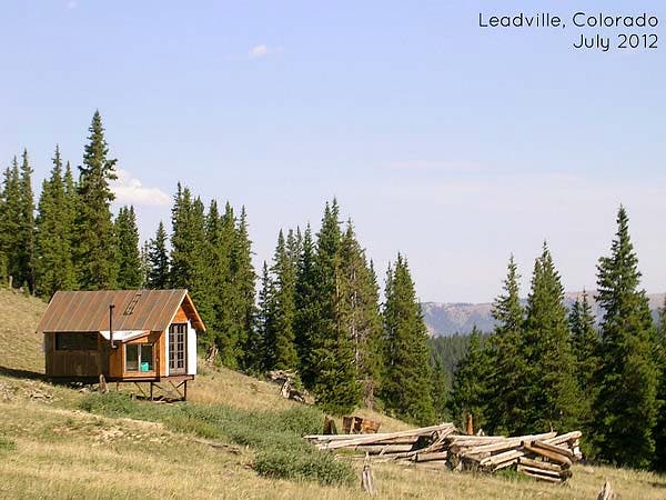
This weeks Tiny House in a Landscape was photographed by Kasey March who is the copy editor for the Tiny House Blog.
Kasey says: Shane and I spotted this tiny house in Leadville, Colorado on our way to a yurt (a story for another time). This little house was about five miles down a dirt road that wound up the mountain. The view was amazing. I didn’t get a good photo but there is a lake directly behind where I stood to take the picture and no other homes in sight. I imagine it’s a very peaceful retreat for someone.
Photo Credit: Kasey March
Hey Kasey,
Do you remember which road you were on? Or even the area or direction you were headed when you saw this house? It’s a great little place, I live near and would like to see it too.
Hey folks! I can’t give the exact location of the tiny house, although Shane’s directions are good (he would know he drove). If you were to visit the Leadville yurts (which we both highly recommend)you’ll see the house during the drive.
Oh and take your jeep in unless you want to park your car and hike in (it’s a long hike).
Oh, I love that. : )
Does anybody know where you can get a metal foundation like that? Seems like that would solve several problems and simplify things all at once!
Perhaps Kasey March could hop onto Google Earth and follow the Road up to the location, and Bookmark where this House is. The collapsed Cabin in the clearing should stand out very clearly, even if the House was not yet built when the Google Earth Image was taken. The Lake adjacent will also provide indexing of the House location. An Image of the location can then be captured and e.mailed to oneself for posting. Or, the Lat/Long Coordinates can be posted instead.
Heh, that precisely what I was doing when I first saw the picture. Unfortunately, there’s a lot of ground to cover and a lot of collapsed cabins to boot.
Shadows are on the left hand side and I believe that the range of mountains in the back is north (and maybe a little east) of Leadville. I’m guessing that the lake they can see is to the right (east or east and south from the cabin) because its really difficult to see lakes on elevations above you ;^) All this places the cabin in question somewhere west of Leadville along the Sawatch range.
I’ve been focused on County Road 4/Hagerman Pass Road which becomes Forest Service Road 105/Frying Pan Road up higher. I’m focused specifically on the area around Hagerman Lake.
I’m not sure if that was my place I’d want it being Google Earth’d for location for the web unless I gave my permission. Just a thought! Great little place.
Agreed, MJ… Someone who built in such a location probably likes their privacy.
Lovely cottage. Very nice pic.
All good points re: Privacy. I was addressing how to answer the question above from ‘Saguache’ if one wanted to. We certainly protect our CO ‘End of the Road’ location, too.
A Forum consideration to ponder in the future is ‘how much info is too much’. From the mention of Leadville; the Lake; the ~5 Mile distance; the collapsed Cabin in front; the Summer Sun angle; and the flat Mountain Range in the background all provided plenty of clues to locate this nice House in a few minutes on Google Earth.
Meh to privacy. it just doesn’t exist any more. I live very near Leadville and would actually like to go see this house. More so because its on a bigger chunk of land that’s obviously not overrun with developers and tourists.
I can’t drive any more so I ride a bike. Isolating the location of a place like this gives me a goal to ride to and will allow me to look for similar land nearby online.
And thanks for the assistance Engineer Guy :^)
Privacy is tough to get these days. The owners were trying. If i’m not mistaken, Leadville is about as far UP as you can go. But, nothing escapes Google Earth. 🙂
Actually, the Country Road nearby the House above is pretty heavily traveled during the short Summers there above 10,000′ elevation. Winters are brutal, and impassable. So, privacy and quiet are all relative, since sound really travels in such Topography.
For folks wanting to check out different areas from the comfort of your Computer – including the ‘lay of the Land’ for Land purchase considerations – Topo Maps are another good resource. They typically show old Cabins, like the one above, and Water Springs, etc.. To me, a very valuable Topo aspect is showing Land slope, and whether Land is Private or Public [say, when sleuthing for the Cabin Site above]. I sussed out our Acreage from 5 hours away, and found on the Topo a Spring in ‘our’ Canyon no one else knew about.
By cross-referencing the visuals of Google Earth with Topos, plenty of knowledge is available from afar. On Google Earth, click on ‘Panoramio’ to then click on and see Photos uploaded of any given area. I do this before planning Boondocking Trips in my lil Trailer.
http://www.topoquest.com/
One of my chief concerns about locating this place or my own is that the area is literally dotted with former mining claims, shafts and old buildings (especially within that ~5 mile radius).
I’m still poking around with topos and Google Earth, but it sure would be mucho helpful if someone knew at least the road we’re looking at this cabin from.
Hint: Its about 1100ft above the Mt. Sherman trailhead.
That should be enough to get you there on google maps… 🙂
Awesome Shane, thanks!